1.- Goal of
ASII product
The aim of this SAFNWC product is an Automatic
Satellite Image Interpretation in terms of conceptual models (CM). CMs are
syntheses of physical processes and the typical features they cause in
satellite images, as well as in other synoptic material like for instance in
numerical model output parameters. A CM diagnosis can be used for a deepening
of synoptic diagnosis and for the early detection of ongoing meteorological
processes, as well as for the determination of the stage of development within
those processes.
PGE10 carries out the recognition of CMs in two
ways:
- ASII: Automatic
Satellite Image Interpretation from MSG SEVIRI satellite data alone
- ASIINWP: Automatic
Satellite Image Interpretation from MSG SEVIRI satellite data supplemented
by typical key parameters from the numerical model output (Numerical model
used: ECMWF)
Basic concept
The basic method is the use of pattern recognition methods,
which are applied to extract fundamental information concerning the shape and
location of typical cloud features. These pattern recognition methods
are:
- Detection of frontal areas
- Detection of S-shaped lines
- Detection of circular-shaped cells
- Detection of black stripes in WV images
- Detection of narrow cloud fibres
- Detection of curvature direction
- Detection of spiral cloud structures
For each CM a combination of necessary and appropriate
pattern recognition methods is applied. For a detailed description of the
pattern recognition methods used for each CM see the relevant chapters in the
User Manual
"(UM v1.0)".
|
Conceptual model
|
Chapter in the User Manual |
| Cold front |
2.4.1.1 |
| Cold front in warm air advection |
2.4.1.1 |
| Warm front |
2.4.1.2 |
| Occlusion |
2.4.1.3 |
| Wave |
2.4.1.4 |
| Developing wave |
2.4.1.4 |
| Upper wave |
2.4.1.5 |
| Front intensification by jet |
2.4.1.6 |
| Dry intrusion |
2.4.1.7 |
| Upper level low |
2.4.1.8 |
| Comma cloud |
2.4.1.9 |
| Enhanced cumulus |
2.4.1.10 |
| Cumulonimbus |
2.4.1.11 |
| Mesoscale convective system |
2.4.1.12 |
| Cold air cloudiness |
2.4.1.13 |
| Fibres |
2.4.1.14 |
| Lee cloudiness |
2.4.1.15 |
Table 1: List of detected conceptual models in
ASII
Introductory steps
After a preprocessing of the IR image, Atmospheric
Motion Vectors (AMV’s) using the standard cross correlation technique are
derived and motion-corrected difference images are computed. Then a basic
pattern recognition method namely image segmentation and classification, is
used. Segmentation divides the IR satellite image into sub-regions being
coherent in terms of brightness and texture. The classification process
assignes qualities of CM’s to these coherent areas.
Pattern recognition methods
Besides the basic pattern recognition methods mentioned
above, more complex pattern recognition methods are summarised below.
- Detection of frontal areas:
The identification of coherent areas of
sufficiently large size plays an important role e.g. in the recognition of
frontal systems and of S-shaped bulges (waves). The number of contiguous
pixels above a certain brightness (temperature) threshold is determined.
Contour lines encircles extended frontal areas. For this process, images
compressed by the Gauss pyramid method are used.
- Detection of S-shaped lines:
The recognition of S shapes is applied to contour
lines. The algorithm for the identification of S-lines is comprised of the
following steps:
- Derivation of the contour lines.
- Through each pixel of a contour line, a batch of
straight lines with given radius and angle increment is constructed.
- If a straight line exists which cuts the contour
line at 3 disjoint locations the presence of an S-line is assumed
- Detection of circular shaped cells:
Convective cells are recognisable by their local
temperature (brightness) maximum and their compact circular or elliptical
shape. The steps of their detection are:
- Extraction of the local temperature minimum
(brightness maximum) being colder (brighter) than a given threshold.
- Around each of these points, a number of concentric
circles with prescribed radii is constructed.
- For each circle, one investigates whether a certain
percentage of all pixels lying on the circle exhibit a minimum difference to
the brightness of the centre. This criterion helps to eliminate homogeneous
and fibrous structures. Each maximum passing the test is marked as the
centre of a convective cell.
- Detection of dark stripes in WV images:
The detection of dark stripes has the following
principal steps:
- For each pixel, it is checked whether the pixel is
dark enough, i.e. whether it is darker than an empirical threshold.
- It is verified for each candidate pixel that it is
darker than most of its neighbours.
- Detection of fibres:
The detection of fibres is based on an algorithm which was
originally developed for the detection of black stripes in WV imagery. The fibre
detection is based on a temperature threshold, a temperature gradient between the fibre
and its surroundings, a radius in which the criterion for fibre is checked and a mesure
for the spatial extension of the fibre.
- Detection of spiral cloud structures:
The detection of cloud spirals is done via the
three following steps:
- Cloud texture:
The method is based on the direction of texture
elements, i.e. the direction in which the local features of the satellite
image appear to be oriented. This parameter can be assessed quantitatively
by applying a Sobel filter to the image, with subsequent filtering of noise
by applying a series of median filters.
- Curvature analysis:
Streamlines of these texture elements are
determined and, finally, the curvature of those streamlines is computed. A
large curvature radius indicates straight streamlines, whereas a strong
curvature is indicative for spiraled cloud features.
- Hough knots:
The final step is obtained via the so-called
Hough knot method. In case of spirals, lines perpendicular to the texture
elements will cut in a point called Hough knot.
3.-
List of inputs for ASII
MSG radiance values:
The following SEVIRI channels are required at full MSG
resolution, for the current and the previous slot:
- R12.0 µm Mandatory
- R10.8 µm Mandatory
- R6.2 µm Mandatory
ECMWF NWP data:
- Mandatory for the ASIINWP product. Required levels:
1000, 850, 700, 500, 400, 300 hPa. Required basic parameters: wind,
temperature, geopotential height, humidity.
4.- Coverage and resolution
The ASII products deal with pattern recognition on a
synoptic scale. For products of this kind, it is beneficial to consider an
area as extended as possible.
The products will be derived every 15 minutes, and the
designations of analysed conceptual models are given on a grid with a mesh
size of ~70 km.
5.-Description of ASII outputs
The ASII and ASIINWP products are output in separate
BUFR files. These files contain a certain number (Version 2.4: 20) of
telegrams which describe the longitudes and latitudes of the grid points where
conceptual models are diagnosed. Details about the template of the BUFR
telegrams can be found in the Algorithm Theoretical Basis Document (ATBD chapter
3.2.2).
6.- Example of ASII visualisation
As example, the 28th March 2011, 13 UTC has
been chosen.
Visualisation of the ASII product (satellite information only):
Several frontal systems are detected showing warm (red w) and cold fronts (blue c).
Lee cloudiness has been detected over southern Italy (yellow L) and and over Iceland.
Two comma clouds (yellow co) were detected over the Arctic Sea and near Ireland.
Visualisation of the ASIINWP product (additional NWP fields):
The ASIINWP analysis shows similar results. Some deviations from the satellite analysis
without model fields can nevertheless be observed. The cold front over Portugal is under warm
air adevction (red c) as well as the cold front between Tunisia and Italy.
For a complete list of the used symbols see table
2.
|
 Click on thumbnail for full-sized image Click on thumbnail for full-sized image
|
|
Figure 1: IR satellite image from 28th
March 2011, 13 UTC analysed by the ASII product.
|
|
 Click on thumbnail for full-sized image Click on thumbnail for full-sized image
|
|
Figure 2: IR satellite image from 28th
March 2011, 13 UTC analysed by the ASIINWP product.
|
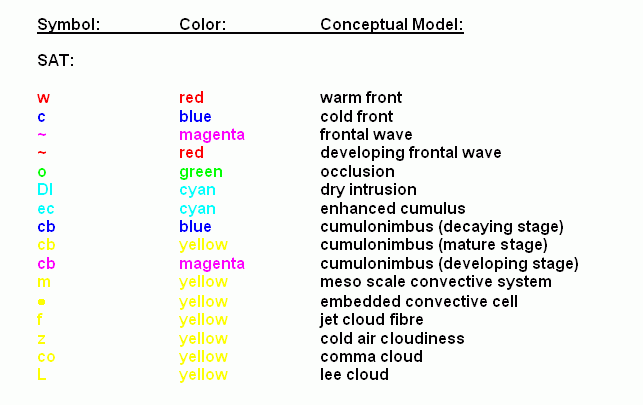
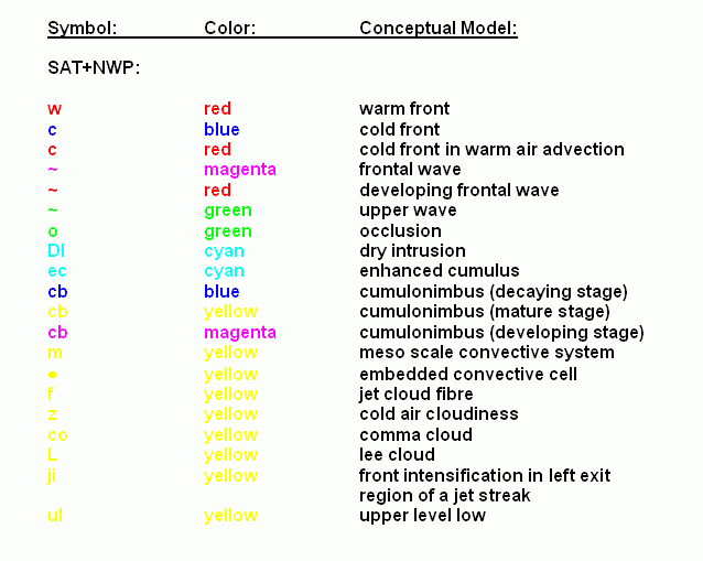
Table 2a and 2b: Symbols used for the visualisation of the ASII
products.
2a: SAT: IR and WV satellite image as sole
input
2b: SAT+NWP: NWP fields are added to the
satellite image data