Convection Initiation (PGE18 V1.0)
v2016
Goal
of the CI product
The CI (Convection Initiation)
product has been developed by
Meteo-France
in the framework of the EUMETSAT SAF in support to Nowcasting. Using
mainly
geostationnary satellite data, it provides
the probability for a cloudy pixel to
become a thunderstorm in a given following period range. The product
aims to catch the first steps of initiation of convection, when the
first convective signs occur after the formation of clouds, or when
those signs appear revealing a modification of environmental
conditions. Probability of the formation of a
thunderstorm depends on evolution of local condition and on advection
of clouds. For this second point, CI is unfortunately too scarce for
a full object-approach that allows a good following of meteorological
systems. CI is a pixel product
CI Algorithm
The process follows :- The
detection of cloud systems
- The
tracking of cloud systems
- The discrimination of convective cloud objects
- The advection of convective cloud objetcs
Areas of interest
This preliminary step requires in optimum configuration
- A first filter is based on 10.8µm BT, to ignore cold cloudy
pixels and focus on early warm stages of cloudy pixels
-
Then, NWP data are used for a guidance when available, to eliminate stable areas and focus on more unstable pixels
- Convective indexes are computed or read from NWP to produce a
convective
/ non convective mask to identify non convective areas
- Only cloud cells out of non convective areas are taken into
account
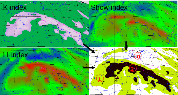
NWP mask : 0 = non convective areas = union of 3 non convective indexes
-
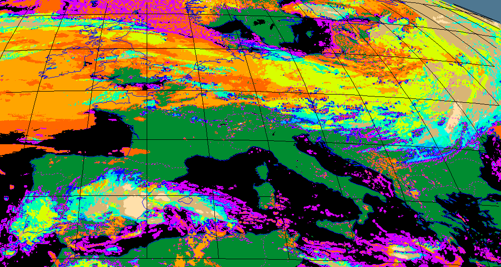
NWCSAF cloud type product is used to eliminate non cloudy areas and focus on cloudy pixels
- Cloud
Type as optional
input, is used to ignore cloud-free areas in the identification of
cloud cells. It
allows CI to focus
on cloudy areas only.
- CI takes into account the deformation of pixels when on the edge of the spaceview domain. A mask of stretched pixels (pixels more than 5 * nominal_area) is automatically elaborated and backuped, and masked zones are ignored.
- Both approaches are merged to focus on areas of interest
 CT product |
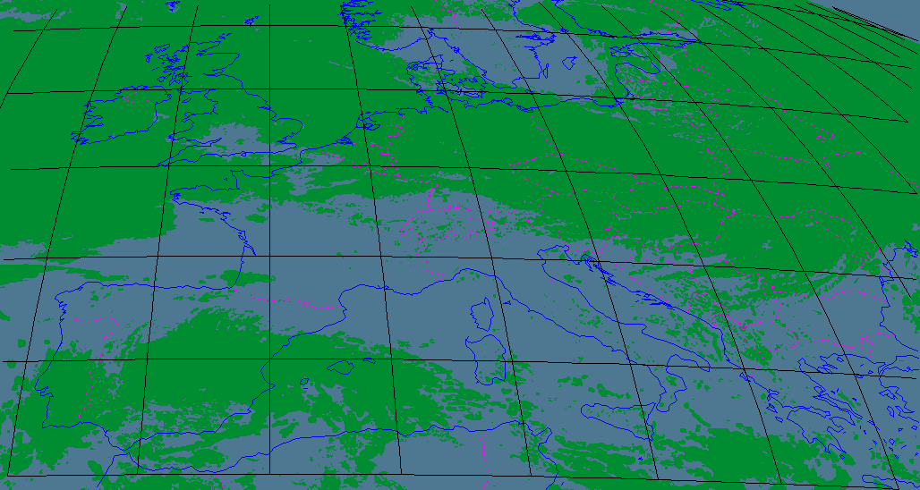 Non cloudy pixels identification |
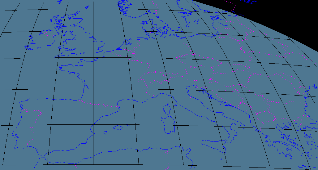 mask for stretched pixels (backup file) |
 stretched pixels + non cloudy pixels |
 IR10.8 image |
 Working image for both object and pixel approach for CI |
Thus, large areas are ignored in the
following processes, which may focus on a restricted set of pixels to
be
analyzed.
2D Movement field
A 2D movement field is estimated in optimum configuration with blending NWP wind field in the low level (850hPa) and last available HRW wind observations, remapped on grid-field and selected versus the corresponding pixel’s brightness temperature. Priority in the blending is given to HRW wind observations, affected to a 9-pixels-box centred on the corresponding pixel.
This blended field is
at first used as
guess movement for initialization in the tracking process of object
analysis (“cold start” cases, or orphan cells).
Then this field is updated with objects movement vectors, to finally be
considered as a pixel tracker for trends calculations.
Object
image analysis: warm cloud cell detection&tracking
An object analysis process is undertaken like in RDT-CW software, but has been adapted to focus on warm cloud cells from lowest layers. The objectives of this step are
-
To take benefit from techniques allowing to catch cloud cells movement
-
To access cloud cells’ parameters variations along its trajectory
More details about tracking can be found in RDT-CW algorithm description.
CI-specificities rely on
-
Specific Cold limit for adaptative thresholding : the limit has been set to -25°C (instead of -75°C for RDT-CW) in order to limit the analysis to lowest levels
-
Minimum vertical extension of objects, which has been set to 3° (instead of 6° for RDT-CW) to focus on lower extended cloud systems
This step takes benefit from movement guess field as input to increase cell’s speed reliability, and on the other hand delivers as output an updated movement field with the analyzed objects’ speeds. All pixels belonging to a tracked cloud system are affected the corresponding movement speed instead of previous pixel’s movement values.
This final blended movement field is a key point for further relevant trends calculations
Pixel
image analysis
Brightness Temperature Differences are processed for each eligible-CI pixel from various available channels, for current data and data from previous slot.
BTDs taken into account are
-
WV6.2-WV7.3,
-
WV6.2-IR10.8
-
IR10.8-IR8.7
-
IR12.0-IR10.8,
-
IR13.4-IR10.8
Then, BT (IR10.8) and BTD trends are calculated for each eligible-CI pixel using the speed and direction of updated 2D movement field as guidance for identifying pairs of current and corresponding pixels in previous image.
When tracking of aggregated pixels (belonging to a tracked cloud system as object) is available, corresponding trends are used for some parameters instead of single pixel-trends, and should be able to provide trends over longer depth.
Interest fields
Each eligible-CI has then a list of BT and BTD values and trends. According to previous studies about convection initiation, parameters are grouped as:
-
Representative for Cloud-top Glaciation
-
IR10.8 Brightness temperature, Time spent below freezing level, IR10.8-IR8.7 BTD
-
Representative for Cloud depth / vertical extension
-
WV6.2-IR10.8 BTD , IR13.4-IR10.8 BTD , IR12.0-IR10.8 BTD
-
Representative for Cloud growth (updraft)
-
All BTDs trends , IR10.8 BT trends
|
Parameter name |
Relevant value |
Meaning |
|
BT IR10.8 |
> -25° |
Brightness temperature (glaciation) |
|
BTZG |
Within 30min |
Time since crossing 0°C (glaciation) |
|
BTD4 |
]-10° , 0°C[ |
IR10.8-IR8.7 (glaciation) |
|
BTD |
]-35° , -10°C[ |
WV6.2-IR10.8 (height) |
|
BTD6 |
]-25° , -5°C[ |
IR13.4-IR10.8 (height) |
|
BTD5 |
]-3° , 0°C[ |
IR12.0-IR10.8 (height) |
|
TxBT 15’ |
] -4°/15’ , -50°/15’[ |
Temperature change rate (growth) |
|
TxBT 30’ |
] -4°/15’ , -50°/15’[ |
Temperature change rate (growth) |
|
TxBTD 15’ |
> 3°/15’ |
BTD 15 Trend (growth) |
|
TxBTD 30’ |
|
BTD 30 Trend (growth) |
|
TxBTD4 15’ |
]0°/15’ , 10°/15’[ |
BTD 15 Trend (growth) |
|
TxBTD5 15’ |
]0°/15’ , 10°/15’[ |
BTD 15 Trend (growth) |
|
TxBTD6 15’ |
> 3°/15’ |
BTD 15 Trend (growth) |
CI diagnosis
CI-diagnosis should be derived from statistical models using Interest fields’ values of pre-CI pixels. Those models will rely on a specific ground truth (high reflectivity from radar data, convective cells from RDT-CW, lightning data). In logistic regression a pixel that belongs to a convective path during a given period will be considered as ground truth. Such a tuning has been postponed to the next release.
Current
CI output is
estimated with empirical rules defined by count of relevant criteria.
The v
-
Nb of Growth relevant parameters (over 3)
Nb of Glaciation relevant parameters (over 3)
Nb of Height relevant parameters (over 4)
Result>or= 2
>or= 3
>or= 4
HIGHPROB
>or= 3
MODPROB
< 3
LOWPROB
>or= 2
>or= 4
MODPROB
>or= 3
LOWPROB
<3
VLOWPROB
>or= 1
>or= 3
>or= 4
MODPROB
< 4
LOWPROB
>or= 2
>or= 4
LOWPROB
>or= 3
VLOWPROB
0
>or= 3
>or= 3
LOWPROB
<3
VLOWPROB
Other cases
0
Empirical rules for CI-diagnosis. HIGHPROB means between 75 and 100%, MODPROB between 50 and 75%, LOWPROB between 25 and 50%, VLOWPROB between 0 and 25%
The output product
The final product concerning CI includes probability of Convective Initiation for 30min, 60min and 90min ranges (resp ci_prob30, ci_prob60 and ci_prob90 Netcdf container). But for this v2016 release, only the first range (ci_prob30) is initialized, other ranges present undefined data.
Data are encoded regarding the correspondance table below.
|
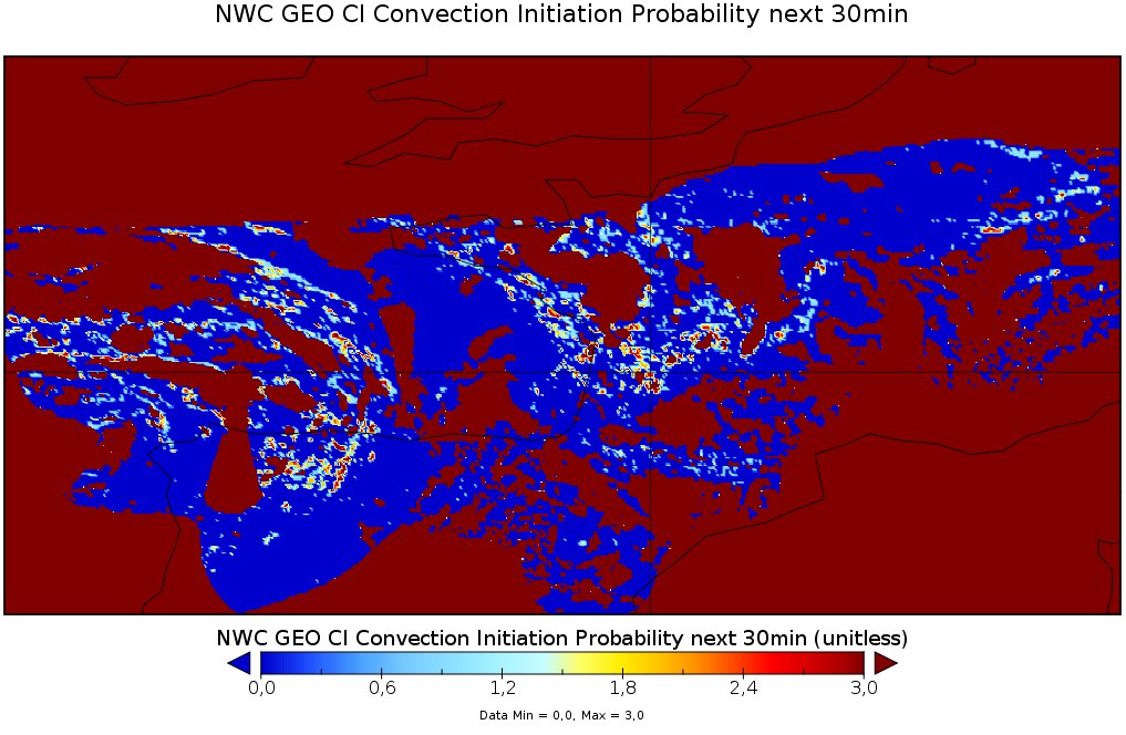 Example of CI probability for next 30min. Here a value of 3 stands for a probability of 75% |
The configuration file
Input Data
SEV_BANDS channel bands to be used by PGE WV62 WV73 IR87 IR108 IR120 IR134CT 0(default) or 1 if using CT product for additional attributes Cloud Type and Cloud Phase
CMa 0(default) or 1 if using CT product for masking non cloud pixels
HRW 0(default) or 1 if using HRW product as guess data for movement estimation
NWP
data parameters
NWP_PARAM NWP_SP
Surface
pressure : resolution(1) and interpolation method(BLI)NWP_PARAM NWP_2T 2m temperature
NWP_PARAM NWP_2D 2m dew point temperature
NWP_PARAM NWP_2RH 2m relative humidity (when available)
NWP_PARAM NWP_SGEOP Surface geopotential height
NWP_PARAM NWP_ALTM altitude of ground (when available)
NWP_PARAM NWP_T temperature at pressure levels specified in nwp_conf_file
NWP_PARAM NWP_RH relative humidity at pressure levels specified in nwp_conf_file
NWP_PARAM NWP_GEOP geopotential height at pressure levels specified in mwp_conf_file
NWP_PARAM NWP_UW U component of wind at pressure levels specified in nwp_conf_file
NWP_PARAM NWP_VW V component of wind at pressure levels specified in nwp_conf_file
NWP_PARAM NWP_LI Lifted index (when available)
NWP_PARAM NWP_KI K index (when available)
NWP_PARAM NWP_SHW Showalter index (when available)
NWPMVTLVL Pressure level of U/V NWP data as guess data for movement estimation (recommanded 850hPa)
Detection
parameters
TCOLD
cold temperature threshold when
multiple thresholding, deg Celsius. Recommended
temperature is -25 degCTWARM warm temperature threshold when multiple thresholding, deg Celsius. Recommended temperature is 10degC
DELTATEMPE temperature step between Tcold and Twarm, deg, default 1
SMIN min detection area , km2, default 1. Recommended value is 1
SMAX max detection area , km2, default no limit. Recommended value is 10 000
Additional options
DBG More precise Informations on program running, default 0 (no information)The Documentation
SAFNWC user
documentation for PGE18:- Product User Manual
- Algorithm Theoretical Basis Document
- Validation Report