HRW v3.0 product (included in NWCSAF v2010) has been run in the Iberian Peninsula & France National area (defined in the $SAFNWC/config directory as spain.cfg) during the days 22nd to 23rd December 2009 to show its possibilities for the watch and warning of dangerous strong wind situations. A larger difference than the default one has been permitted between the HRW wind components and the ECMWF wind guess used for their calculation, up to 144 km/h through configuration parameters LLAG_HRV = ELAG_HRV = 72; LLAG_IR = ELAG_IR = 24).
Filtering out the HRW output, and considering only the strongest winds in the Very low layer (850-1000 hPa), a narrow area of Hurricane force winds (i.e. 15 minute mean winds with speeds between 125 and 150 km/h) is detected coming from the Atlantic Ocean into Portugal, related to the area where the main damages in Portugal occurred. Hurricane force winds at this layer (850-1000 hPa) caused by the pass of a prior low during the afternoon of the 22nd of December, can also be seen from the Strait of Gibraltar eastwards throughout all the Spanish Mediterranean, including the southern part of the Sea Area of Cabrera where Category II Hurricane force winds (15 minute mean winds stronger than 154 km/h) were measured by HRW product.

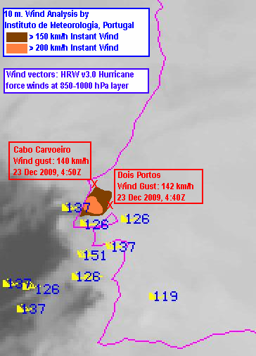
| Only two surface wind observations were available for the
study region in Portugal, with wind gusts around 140 km/h: Cabo
Carvoeiro and Dois Portos.
A later analysis of surface winds, considering the extrapolation of Doppler Radar winds by the Portuguese Instituto de Meteorologia available here, shows small areas within the study region with 10 meter maximum winds stronger than 150 km/h and 200 km/h around 04:30, 23 December 2009. |
|
The Very low layer Hurricane force wind areas in Portugal and the Mediterranean shown by NWCSAF/HRW product were not identified by the ECMWF model wind guess used by the algorithm. The wind fields shown by the model guess were throughout both days clearly weaker than the winds shown by HRW product. ECMWF model only shows 925 hPa Hurrican force winds in a small area in the southern flank of the low at 23 December 00:00, with a reduction in the wind force and a more southerly location of the wind maximums at 06:00 (with maximum winds located over the Gulf of Cádiz instead of the described area in Portugal). Because of this, while no hint can be extracted from the model about the areas suffering the strongest winds in Portugal, they are clearly detected with HRW output.

Considering the wind fields in the Mediterranean the afternoon and evening of the 22nd December, the Hurricane force winds at the layer 850-1000 hPa shown by HRW product throughout all the Sea Areas between the Strait of Gibraltar and the Balearic Islands are much stronger than the corresponding ECMWF 925 hPa wind fields, which only show maximum wind speeds around 110 km/h at 22rd December 18:00, and smaller to 100 km/h at all other times.
Because of this, HRW product can be very helpful in the Nowcasting of dangerous wind situations, beyond the possibilities of the NWP models used for HRW calculation.