
Cloud Mask (GEO v2021)
Table of contents
Access to "Algorithm Theroretical Basis Document for Cloud Products Processors of the NWC/GEO" for a more detailed description.
1. Goal of CMA product
The cloud mask (CMA), developed within the SAF NWC context, aims to support nowcasting applications, and additionally the remote-sensing of continental and oceanic surfaces. The CMA allows identifying cloud free areas where other products (total or layer precipitable water, land or sea surface temperatures, snow/ice cover delineation) may be computed. It also allows identifying cloudy areas where other products (cloud types and cloud top temperature/height) may be derived.
The central aim of the CMA is therefore to delineate all cloud-free pixels in a satellite scene with a high confidence. In addition, the product provides information on the presence of snow/sea ice, dust clouds and volcanic plumes.
2. CMA algorithm summary description
The algorithm is based on multispectral threshold technique applied to each pixel of the image.
A first process allows the identification of pixels contaminated by clouds or snow/ice. It consists in a series of tests applied to various channels combination for each pixels of the current slot. This is complemented by an analysis of the temporal variation (on a short period of time: around 15 minutes depending on the satellite) of some spectral combination of channels (to detect rapidly moving clouds), a specific treatment combining temporal coherency analysis and region growing technique (to improve the detection of low clouds), a temporal analysis of the high resolution visible channel (on SEVIRI: HRV) to detect sub-pixel cumulus clouds and finally a second limited set of multispectral tests with thresholds computed from RTTOV applied on-line to NWP vertical profiles to allow a more accurate detection of low or thin high clouds that remained undetected. The characteristics of the first set of tests are summed up below:
-
The tests, applied to land or sea pixels, depend on the solar illumination and on the viewing angles (daytime, night-time, twilight, sunglint, as defined in table 1) and are presented in tables 2 and 3.
-
Most thresholds are determined from satellite-dependent look-up tables using as input the viewing geometry (sun and satellite viewing angles), NWP forecast fields (surface temperature and total atmospheric water vapour content) and ancillary data (elevation and climatological data). The thresholds are computed at a spatial resolution defined by the user as a number of SEVIRI infra-red pixels. Some thresholds are empirical, constant or satellite-dependent values.
-
The quality of the cloud detection process is assessed by analysing how close the measurements and the thresholds are from each other.
This first process allows to determine the cloud cover category of each pixel (cloud-free, cloud contaminated, cloud filled, snow/ice contaminated or undefined/non processed) and compute a quality flag on the processing itself. Moreover, the tests that have allowed the cloud detection (more that one test are possible, if some tests were not really successful) are stored.
A second process, allowing the identification of dust clouds and volcanic ash clouds, is applied to all pixels (even already classified as cloud-free or contaminated by clouds). The result is stored in the dust cloud and volcanic ash cloud flags.
Details on the algorith are available in the Algorithm Theoretical Basis Document, that can be downloaded from this web page.
| Nighttime | Twilight | Daytime | Sunglint |
| Solar elevation < -3° | -3° < Solar elevation < 10° | 10° < Solar elevation | Cox & Munck > 10% |
Table 1: Definition of illumination conditions
Cox & Munck stands for the reflectance computed using Cox & Munck theory; the solar elevation is expressed in degrees.
| Daytime | Twilight | Nighttime |
| Snow detection | Snow detection | T10.8µm-T3.8µm |
| R0.6µm | R0.6µm | T10.8µm |
| T10.8µm | T10.8µm | T10.2µm-T12.0µm |
| T10.8µm-T12.0µm | T10.8µm-T12.0µm | T8.7µm-T10.8µm |
| T8.7µm-T10.8µm | T10.8µm-T3.8µm | T3.8µm-T10.8µm |
| T10.8µm-T3.8µm | T8.7µm-T10.8µm | Local Spatial Texture |
| T3.8µm-T10.8µm | T3.8µm-T10.8µm | T8.7µm-T3.8µm |
| R1.38µm | Local Spatial Texture |
|
| Local Spatial Texture | T8.7µm-T3.8µm |
|
Table 2: Test sequence over land
| Daytime | Sunglint | Twilight | Nighttime |
| Ice detection | Ice detection | Ice detection | T10.8µm-T3.8µm |
| R0.8µm (R0.6µm) | SST | R0.8µm (R0.6µm) | SST |
| SST | T10.8µm-T12.0µm | T10.8µm-T3.8µm | T8.7µm-T10.8µm |
| R1.6µm | T8.7µm-T10.8µm | SST | T10.8µm-T12.0µm |
| T10.8µm-T12.0µm | Local spatial texture | R1.6µm | T12.0µm-T3.8µm |
| T8.7µm-T10.8µm | R0.8µm (R0.6µm) | T8.7µm-T10.8µm | T3.8µm-T10.8µm |
| T10.8µm-T3.8µm | T10.8µm-T3.8µm | T10.8µm-T12.0µm | Local spatial texture |
| T3.8µm-T10.8µm | Low clouds in sunglint | T12.0µm-T3.8µm |
|
| R1.38µm |
| T3.8µm-T10.8µm |
|
| Local spatial texture |
| Local Spatial Texture |
|
Table 3: Test sequence over sea.
[T3.8µm, T8.7µm, T10.8µm, T12.0µm stand for brightness temperatures at 3.8, 8.7, 10.8 and 12.0 micrometer; R0.6µm, R0.8µm, R1.38µm and R1.6µm stand for VIS/NIR bi-directional top of atmosphere reflectances at 0.6, 0.8, 1.38 and 1.6 micrometer normalised for solar illumination; SST is the split-window (used for SST calculation) computed from T10.8µm and T12.0µm measurements. Low Clouds in Sunglint is a specific module for low clouds identification in sunglint areas.]
3. List of inputs for CMA
Mandatory inputs are flagged, whereas the impact of missing non-mandatory data on the processing are indicated.
Satellite imagery
The following satellite bi-directional reflectances or brightness temperatures are needed at full IR spatial resolution (at HRV spatial resolution for HRV):
| HRV | R0.6µm | R0.8µm | R1.38µm | R1.6µm | R2.25µm | T3.8µm | T8.7µm | T10.4µm | T10.8µm | T12.0µm | T13.4µm |
|
| Mandatory |
|
|
|
| Mandatory |
|
| Mandatory | Mandatory |
|
The CMA software checks the availability of channels for each pixel. If non mandatory channels are missing for one pixel, the tests using these channels are not applied, or applied differently (for example, snow detection uses either R1.6µm or T3.8µm; visible channel test over the ocean uses either R0.8µm or R0.6µm) and a result is available for this pixel. No results are provided for pixels where at least one mandatory channel is missing.
The following bi-directional reflectances or brightness temperatures or CMA or CT of the scene analysed one hour sooner are optionnaly needed to improve the cloud detection in day-night transition. If one is missing this improvement is not performed.
| R0.6µm (1h) | T8.7µm (1h) | T10.8µm (1h) | T12.0µm (1h) | CMA (1h) | CT (1h) |
|
|
|
|
|
|
|
The following brightness temperatures or CMA or CT of the scene analysed 15 minutes sooner are optionnaly needed to improve the cloud detection of fast moving clouds. If one is missing this improvement is not performed.
| T8.7µm (15mn) | T10.8µm (15mn) | T12.0µm (15mn) | CMA (15mn) | CT (15mn) |
|
|
|
|
|
|
The HRV bi-directional reflectances of the scene analysed 15 minutes sooner are optionnaly needed to improve the sub-pixel cumulus cloud detection. If not available, this improvement is not performed.
The satellite channels are input by the user in HRIT format (or netcdf format for foreign satellites), and extracted on the processed region by NWC/GEO software package.
Sun and satellite angles associated to satellite imagery
This information is mandatory. It is computed by the CMA software itself, using the definition of the region and the satellite characteristics.
NWP parameters
The forecast fields of the following parameters, remapped onto satellite images, are used as input :
- surface temperatures (required to get good quality results over land; but not mandatory)
- air temperature at 950hPa (alternatively 925hPa). Used to check low level inversion.
- total water vapour content of the atmosphere,
- altitude of the NWP model grid (alternatively surface geopotential on the NWP model grid). Required if NWP fields are used as input.
These remapped fields are elaborated by the NWC/GEO software package from the NWP fields input by the user in GRIB format.
The NWP fields are not mandatory: the CMA software replaces missing NWP surface temperatures or total water vapour content of the atmosphere by climatological values extracted from ancillary dataset, but the quality of CMA is then lower.
RTTOV simulations
The following parameters simulated by RTTOV are used as input :
- clear sky top of atmosphere radiance
- transmittance from surface to TOA
- clear sky downwelling radiance
These remapped fields are elaborated by the NWC/GEO software package by applying RTTOV to the NWP fields input by the user in GRIB format.
The RTTOV simulations are not mandatory: if not available, the GEO-CMA software does not apply corresponding tests, the GEO-CMA quality being then slightly lower (especially in nightime conditions).
OSTIA fields
The following parameters are used as input :
- OSTIA sst and local estimated error
High resolution global daily bulk SST fields (OSTIA) are input by the user who can obtain them from MyOcean service desk (see http://www.myocean.eu.org). They are used in conjunction with RTTOV simulations.
These OSTIA fields are not mandatory: if not available the RTTOV simulations are not used over ocean and the CMA software does not apply corresponding tests, the GEO-CMA quality being then slightly lower (especially in nightime conditions).
RTTOV bias file
RTTOV bias files are used as input. They can be downloaded from AEMET ftp server. They are valid only for ECMWF model.
These files are not mandatory. If not available, the bias can be computed by GEO-CMA (the processed region needs to contain large enough area covered by oceanic surfaces. If this computation is not possible, the GEO-CMA does not apply test using RTTOV simulation and the GEO-CMA quality being then slightly lower (especially in nightime conditions)).
Ancillary data sets
The following ancillary data, remapped onto satellite images, are mandatory :
- Land/sea atlas
- Land/sea/coast atlas
- Elevation atlas
- Monthly SST minimum and standard deviation values climatology
- Monthly mean 0.6µm atmospheric-corrected reflectance climatology (land)
- Monthly mean visible surface reflectance climatology for HRV processing (derived from monthly MODIS black-sky albedos at 0.55µm, 0.67µm and 0.86µm)
- Land cover database (BATS)
- Monthly integrated atmospheric water vapor content climatology
- Monthly climatology of mean air temperature at 1000 hPa
- Monthly thermal emissivity at IR wavelength
These ancillary data are available in the NWC/GEO software package at a global scale; they are remapped on the satellite full disk by NWC/GEO remapping functionality.
Coefficients's file (also called threshold tables), containing satellite-dependent values and look-up tables for IR thresholds and for solar channels' thresholds, are available in the NWC/GEO software package, and are needed by the CMA software.
4. Coverage and resolution
The CMA software has been designed to allow the processing at SEVIRI IR full spatial resolution of any rectangular areas defined by the user inside the MSG full disk (the processing of the MSG full disk is also possible). The validity of the CMA product is commited inside the MSG full disk.
The CMA software is adapted to other GEO satellites (GOES16/17 and Himawari8/9)
5. Description of CMA outputs
CMA product are coded in NetCdF format and include :
Cloud/snow mask
| FillValue | Non-processed | containing no data or corrupted data |
| 0 | Cloud-free | no contamination by snow/ice covered surface, no contamination by clouds ; but contamination by thin dust/volcanic clouds not checked |
| 1 | Cloud | cloud (except thin ice cloud over snow) |
| 2 | thin cloud over snow | thin ice cloud over snow |
| 3 | Snow/Ice contaminated |
|
Volcanic ash flag
| FillValue | Non-processed | containing no data or corrupted data |
| 0 | No volcanic plume |
|
| 1 | Volcanic plume |
|
| 2 | undefined | separability problems |
Dust flag
| FillValue | Non-processed | containing no data or corrupted data |
| 0 | No dust |
|
| 1 | dust |
|
| 2 | undefined | separability problems |
6. Example of CMA visualisation
It is important to note that the CMA product is not just images, but numerical data. At first hand, the CMA is rather thought to be used digitally (together with the appended flags (quality, dust detection, volcanic ash detection) as input to mesoscale analysis models, objective Nowcasting schemes, but also during the extraction of other SAFNWC products (CT for example).
Colour palettes are included in CMA NetCdF files, allowing an easy visualisation of CMA main categories, dust and volcanic ash clouds flags.
No examples of CMA main categories are given, as it is thought that the user will be more interested to visualize the CT product which can be seen as a refinement.
Examples of visualisation of the dust cloud and the volcanic ash clouds flags superimposed on an infrared image are presented, using SEVIRI and MODIS imagery.
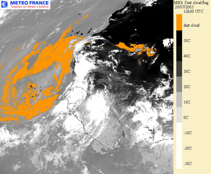
Click on thumbnail for full-size this image
Example of SEVIRI dust cloud flag superimposed on a 10.8µm infrared image: 20th July 2005 at 12h00 UTC.
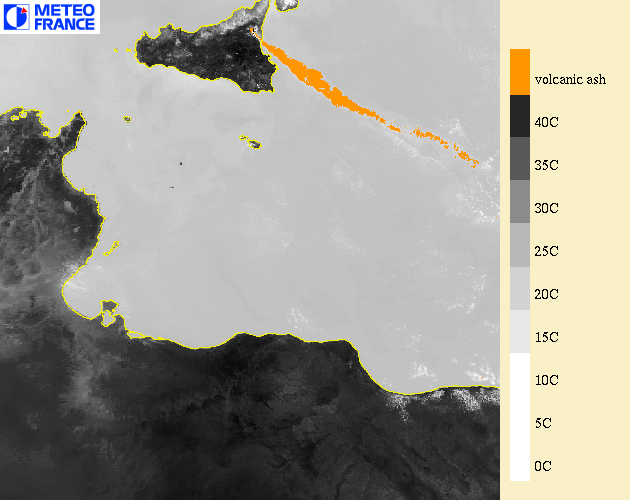
Click on thumbnail for full-size this image
Example of MODIS volcanic ash cloud superimposed on a 10.8µm infrared image: Etna eruption on 22nd July 2001 at 9h55 UTC