 Precipitating Clouds
PGE04 SAFNWC
Table of contents
1. Goal of PC product
2. PC algorithm summary description
3. List of inputs for PC
4. Coverage and resolution
5. Description of PC outputs
6. Example of PC visualisation
Access to "Algorithm Theoretical Basis Document for SAFNWC/MSG "Precipitating Cloud" (PC-PGE04 v1.5)" for a more detailed description.
1. Goal of PC product
The objective of the PC product is to support detailed precipitation analysis for nowcasting purposes. The focus is on the delineation of non-precipitating and precipitating clouds and not on quantifying precipitation amount. Particular attention will be given to also identifying areas of light frontal precipitation.
The product provides probability results for precipitation occurance. It is not intended to provide information on the type of precipitation.
2. PC algorithm summary description
The precipitating clouds product gives the likelihood of precipitation. A linear combination of those spectral features, which have the highest correlation with precipitation, is used to construct a Precipitation index PI. For each value of the PI, the probability of precipitation in the respective classes is then determined from a comprehensive dataset of collocated satellite data, precipitation rates from surface radar and surface temperatures from NWP. Special attention has been given to spectral features in the visible, which implicitly contain information on cloud microphysical properties at the cloud top, such as optical thickness, effective radius and cloud phase. The algorithm to retrieve information on the presence of precipitation is based on the Cloud Type output. The algorithm relies much on the microphysical information available in both the 1.6 micron and 3.9 micron channels. For each algorithm a day and a night version exists. The threshold at which sun zenith angle to switch from day to night algorithm is configurable.
3. List of inputs for PC
Satellite imagery
- Meteosat visible and IR channels:
- Daytime: vis0.6, NIR1.6, IR3.9, IR6.2, IR7.3, IR10.8, IR12.
- Nighttime: IR6.2, IR7.3, IR10.8, IR12.0
NWCSAF/MSG Products used as inputs
- Cloud Type product (CT)
Auxiliary data
- NWP surface temperature
- Sun zenith, satellite view zenith, and sun-satellite view relative azimuth difference angle
4. Coverage and resolution
- The product is extracted in full SEVIRI pixel resolution using the satellite projection.
- The region for processing is user defined.
5. Description of PC outputs
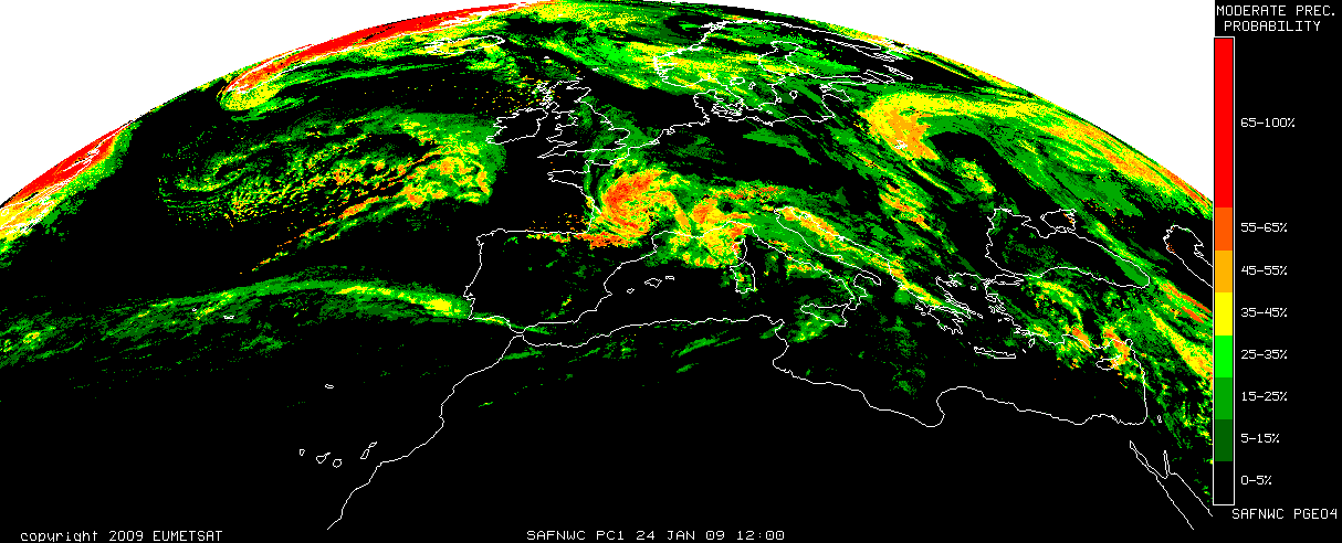
The PC product consists of a numerical value for the likelihood of precipitation. The likelihood is given in intervals of 10%.
The following intervalls of likelihood are used:
0% (= 0-5%)
10% (= 5-15%)
20% (= 15-25%)
30% (= 25-35%)
40% (= 35-45%)
50% (= 45-55%)
60% (= 55-65%)
70% (= 65-75%)
80% (= 75-85%)
90% (= 85-95%)
100% (= 95-100%)
In the PC product is also included a processing flag summarising processing conditions for each pixel.
6. Example of PC visualisation

Precipitation likelihood from MSG day time algorithm (most northern part night algorithm), 24 January 2009, 12:00
