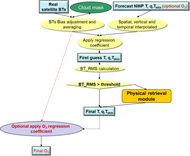
The flow chart of the iSHAI algorithm can be seen in the Figure 1 below.
Figure 1: iSHAI flow chart
Below, the main steps in
the algorithm are described. The whole process includes the
following main steps:
Pre-processing:
• Initialisation:
Reading of processing options from the configuration file, reading of all coefficient file names, initialisation of RTTOV-11.2, getting real satellite BTs, associated geographical ancillary files, IR emissivity maps and CMA for region to process.
The second argument in GEO-iSHAI program is the name of region to process.
The configuration file (extension *.cfm) is an ASCII file that contains all coefficient file names, processing options, etc. The name of the configuration file is the third argument in GEO-iSHAI program.
The keywords with the name of coefficients files are:
FG_reg_T_filename, FG_reg_logq_filename, FG_reg_logOzone_filename, FG_reg_SKT_filename, EOF_FILENAME, Binverse_covariance_matrix_filename, Einverse_covariance_matrix_filename
• Optional thinning of real satellite BTs to process on FOR of M x N pixels (M and N configurable parameters in the configuration file).
The default number is 3x3. Keywords: LSIZE_FOR, CSIZE_FOR
• Selection of method to calculate BTs of the FOR:
The keyword FOR_METHOD is used to select this.
Two methods are available:
1) mean value of clear pixels BTs on FOR (default)
2) BTs of the warmest clear pixel at the cleanest channel in the IR window (IR10.8 in SEVIRI case; IR10.4 in AHI case; IR10.3 in AHI case) .
• To get collocated background NWP forecast temperature and moisture profiles (also ozone if TOZ calculation is activated).
Background NWP fields of temperature and humidity (t+00 to t+24 hours range forecast) must be spatially, temporally and vertically interpolated to get collocated T/q (and optionally ozone) profiles to the pixel position and time.
Depending on the vertical representation of NWP profiles there are two execution modes (P and HYBrid mode). The selection of the mode is made with keyword NWP_EXEC_MODE. The default is P mode.
In the case of P mode: The spatial (horizontal) and temporal interpolation is made outside of GEO-iSHAI reading the files generated by the pre-processing tool AllMappingNWP with common functions of NWC/GEO NWCLIB library. It is the default is mode.
The vertical interpolation to 54 pressure levels of RTTOV is made from the user profile at fixed levels. The selection of the fields to use is made using the keywords NWP_PARAM. There are several “NWP_PARAM” keywords with three arguments to select the parameter, the spatial thinning and spatial interpolation.
Conversion from relative humidity to specific humidity is made by the AllMappingNWP tool.
In the case of HYB mode: all the NWP process is made inside the GEO-iSHAI code.
GEO-iSHAI open directly the previous and next ECMWF GRIB files on hybrid levels to the time of the image, makes the vertical interpolation on ECMWF position to the 54 RTTOV-11.2 pressure levels, makes the temporal interpolation to the date of the image and finally makes the spatial interpolation just over the clear air processed FOR.
The selection of the fields to use is made using the keywords NWP-HYB_*. There are several “NWP-HYB_*” keywords with two arguments to select the parameter and GRIB code.
The specific humidity profile is read from the ECMWF GRIB files on hybrid levels and the conversion from relative humidity to specific humidity is not needed.
• Bias adjustment of the real satellite BTs.
The bias correction regression coefficients are read from the common NWC/GEO files and BT bias correction is made
• Execution of non linear regressions to calculate the first guess profiles of temperature and specific humidity. The non-linear regression step using as main inputs: a) real bias corrected satellite BTs and b) the background NWP temperature and specific humidity profiles spatially, temporally and vertically interpolated to the time and position of the pixel (or FOR). In the GEO-iSHAI ATBD are described the non-linear regressions used to calculate the First-Guess. Same process to calculate the first guess of the skin temperature.
The keywords with the name of FG regression coefficients files are: FG_reg_T_filename, FG_reg_logq_filename and FG_reg_SKT_filename
• Calculation of synthetic RTTOV BTs from first guess profile.
Processing:
The
processing step depends on the distance (BT_RMS) between the satellite
bias corrected BTs and synthetic BTRTTOV over non
window channels:
If the calculated error between RTTOV BTs from first guess profile and the satellite bias corrected BTs (over non window channels) are less than a predefined threshold the Physical Retrieval module is not executed (keyword: BT_RMS_THRESHOLD).
If the calculated error between RTTOV BTs from first guess profile and the satellite bias corrected BTs (over non window channels) are greater than a predefined threshold the Physical Retrieval module is executed (keyword: BT_RMS_THRESHOLD).
In the Physical Retrieval Module the physical retrieval is an optimal estimation iterative process (see GEO-iSHAI ATBD); the physical retrieval iterative process is executed while the error between the satellite bias corrected BTs and synthetic RTTOV calculated from the (T, q) profile after the iteration is greater than a threshold (keyword: MAX_RESIDUAL) and while the maximum number of iterations is not reached (keyword: MAX_ITERATIONS)
If activated by the user, the ozone profile is retrieved using non-linear regression. It is an estimated ozone profile using as main inputs: a) bias corrected real satellite BTs using also the IR ozone absorption channel and b) the background NWP ozone profile spatially, temporally and vertically interpolated to FOR and the retrieved temperature and humidity profile and the retrieved SKT.
To activate the calculation of TOZ, it is needed to change keyword TOZ_CALCULATION to 1 and to include an ozone profile in the GRIB files supplied to NWC/GEO in fixed pressure levels or hybrid levels. The keyword with the name of ozone regression coefficients files is FG_reg_logOzone_filename
The software performs a direct calculation of TPW, LPWs, LI, SHW and KI parameters at FOR from the retrieved profiles of T and q. SKT is one parameter in the structure with profiles.
The software computes the differences
between the products (TPW, LPWs, LI, SHW and KI) calculated from
retrieved profiles of T and q, and the ones calculated from the
background NWP profiles of T and q. Calculate the difference
between SKT and the background NWP SKT.
• If activated, TOZ calculation, to compute TOZ and the differences between TOZ calculated from retrieved profiles of ozone and the ones collocated from the background NWP profiles of ozone.
Optional writing of the intermediate T, q and ozone profiles at the different algorithm steps is possible. Also other parameters as surface pressure, skin temperature, real satellite BTs, ancillary files, etc are written. The profiles are written at the 54 RTTOV levels at the different algorithm steps (after physical retrieval, after iterations, after First-Guess or the background NWP). If activated in the configuration file these optional binary files are written in the $SAFNWC/tmp. The keywords to activate the optional binary files are SAVE_PROFs_in_BINARY_files, SAVE_iSHAI_in_BINARY_file.
Post-processing:
A post-processing to add quality fields and fields needed in order the iSHAI netCDF to be self-contained
Quality control: Several quality flags have been added to the output product.
Filling clear pixels inside the FOR: The default method is to copy the same value to all clear pixels in the FOR. The other configurable option is to write the output only at the warmest clear pixel position in the FOR (the warmest clear pixel at the cleanest channel in the IR window). Keyword: POST_PROC_METHOD
Over cloudy pixels, one IR BT channel degraded to 7 bits (range [0 – 127]) values is stored. This will be later used to generate adequate images in which cloudy pixels are grey scaled and clear pixels are colour scaled. The number of the IR BT channel is configurable using the keyword BAND_CLOUDY; by default in the SEVIRI case is 16, which means IR10.8 channel (in AHI case is 15 which means IR10.4; in ABI case is 15 which means IR10.3) .
The iSHAI outputs are written in a netCDF file.
Full details of the algorithm can be found in "Algorithm
Theoretical Basis Document for iSHAI Product”
Note: in the GEO-iSHAI ATBD there is a similar description of the iSHAI algorithm where the theoretical aspects at each step can be found.