
Automatic Satellite Image Interpretation - In-flight icing potential
NWCSAF/GEO v2025
Table of Contents
1. Goal of the ASII-ICE products
2. ASII-ICE algorithm summary description
3. List of inputs for ASII-ICE
4. Coverage and resolution
5. Description of ASII-ICE output
6. Examples of ASII-ICE visualisation
Access to "Algorithm Theoretical Basis Document for the "Automatic Satellite Image Interpretation - Next Generation" Processor of the NWC/GEO" for a more detailed description.
1. Goal of the ASII-ICE products
In contrast to the former ASII product (removed from the portfolio from v2025 onwards), where the focus was on identification of conceptual models, the next-generation ASII-NG product group in its current stage is clearly linked to in-flight threats, which makes it relevant for meteorologists and aviation end users.
Icing on the planes’ hull (body and wings) during flight occurs when super-cooled water droplets rapidly cause intense ice build-up. Ice aggregation on the wings of airplanes leads to a degradation of the stall characteristics, reduces lift and increases the weight of the airplane. Icing can also affect the jet engine, instruments, visibility and radio communication. It can be the cause for vibrations of the propeller and even block the rudder unit.
Ice crystal icing in high altitudes also presents a threat to airplanes flying near convective weather systems. The main risk of encountering high ice crystal concentrations appears to be downwind from the tops of large areas of convective clouds. High-altitude ice crystals will not adhere to the external airframe or protrusions from it, even though these are considerably warmer than the ambient temperature because of kinetic heating. Actually, they deposit on relatively warm surfaces within the forward part of a gas turbine engine, causing malfunction and a gradual reduction in engine thrust.
2. ASII-ICE algorithm summary description
The module to detect supercooled water droplets employs the decision tree published in Smith et al. (2012).
The detection of high altitude ice crystals basically applies threshold levels to cloud top temperature, cloud optical thickness, liquid water path and ice water path, following the scheme of de Laat et al. (2017).
3. List of inputs for ASII-ICE
- NWC/GEO Cloud Top Temperature and Height product
- NWC/GEO Cloud Microphysics product
4. Coverage and resolution
- The products are extracted in full image resolution using the satellite projection.
- The region for processing is user-defined.
- Since the mandatory input "NWC/GEO Cloud Microphysics" is currently not available in nighttime conditions, both ASII-ICE products are restricted to daytime conditions.
5. Description of ASII-ICE output
The ASII-NG products are encoded in standard NWCSAF netCDF output files. Apart from the standard fields, the ASII-ICE netCDF files hold
- the derived probability of icing due to supercooled water droplets and an indication on its strength ("no icing", "low probability of light icing", "medium probability of light icing", "high probability of light icing", "high probability of medium-or-greater icing", "unknown").
- a flag indicating whether icing due to high-altitude ice crystals is likely or not ("icing" vs. "no icing" plus category "product outage")
Additionally, status flags are provided to give details on processing issues.
6. Examples of ASII-ICE visualisation
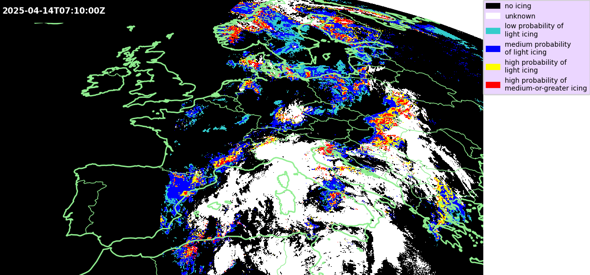
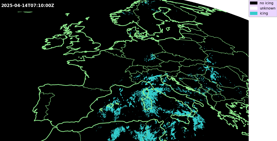
Figure 1: Case of 14 April 2025, 0710 UTC. Upper panel: MTG-I1 ASII-ICE "supercooled water droplets" product. Lower panel: MTG-I1 ASII-ICE "high-altitude ice crystals" product.