
Cloud Microphysics (GEO v2021)
Table of contents
1. Goal of CMIC product
2. CMIC algorithm summary description
3. List of inputs for CMIC
4. Coverage and resolution
5. Description of CMIC outputs
6. Example of CMIC visualisation
Access to "Algorithm Theroretical Basis Document for Cloud Products Processors of the NWC/GEO" for a more detailed description.
1. Goal of CMIC product
The cloud Microphysics (CMIC), developed within the SAF NWC context, aims to support nowcasting applications. The main objective of this product is to provide detailed information on the cloud microphysics. It may be used as input to an objective meso-scale analysis (which in turn may feed a simple nowcasting scheme), as an intermediate product input to other products (such as precipitation), or as a final image product for display at a forecaster desk. The CMIC product is useful for the identification of precipitation clouds and useful for characterisation of rapidly developing thunderstorm.
The CMIC product contains information on the cloud top microphysics for all pixels identified as cloudy in the satellite scene.
2. CMIC algorithm summary description
The cloud top phase is first retrieved by an empirical use of T8.7µm-T10.8µm, T10.8µm and the CT cloud type itself complemented by an combined analysis of 0.6µm, 1.6µm and 2.25µm measured and simulated reflectances, as summarized below:
- Warm (respectively cold) opaque clouds are supposed to be constituted of water (respectively ice) particles, whereas the temperature range between 0 ºC and -40 ºC may correspond to both (or a mixture) of water or ice clouds.
- Cloud classified as semi-transparent in CT cloud type are supposed be constituted of ice particles. Cloud classified as fractional may correspond to thin cirrus or sub-pixel low clouds; their retrieved cloud phase is therefore set undefined.
- Water clouds usually have low T8.7µm-T10.8µm and ice clouds rather high values. Simple viewing angle-dependant thresholds subjectively defined from SEVIRI observations are applied to identify obviously water or ice clouds.
- If the cloud top phase is still not determined, the comparison of observed and simulated 0.6µm, 1.6µm and 2.25µm reflectances for cloudy pixels may allow retrieving the cloud top phase (but ambiguous situations may still exists). This step is applied only in daytime conditions.
Once the cloud phase has been determined, the optical depth and the particle size are obtained using the measured and the simulated 0.6µm and 1.6µm reflectances (only in daytime conditions).
Finally liquid and ice water path are obtained from optical depth and the particle size by empirical formula (only in daytime conditions).
3. List of inputs for CMIC
Mandatory inputs are flagged, whereas the impact of missing non-mandatory data on the processing are indicated.
Satellite imagery
The following satellite brightness temperatures and radiances are needed at full IR spatial resolution:
| R0.6µm | R1.6µm | R2.25µm | T8.7µm | T10.8µm |
| Mandatory | Mandatory | | Mandatory | Mandatory |
The CMIC software checks the availability of satellite brightness temperatures and radiances for each pixel. Full CMIC product is computed only if all mandatory satellite reflectances and brightness temperatures are available.
The satellite channels are input by the user in HRIT format (or netcdf format for foreign satellites), and extracted on the processed region by NWC/GEO software package.
CT and CTTH cloud categories
The CT and CTTH cloud categories are mandatory. They are computed by the CT and CTTH software.
Satellite angles associated to satellite imagery
This information is mandatory. It is computed by the CMIC software itself, using the definition of the region and the satellite characteristics.
NWP parameters
The forecast fields of the following parameters, remapped onto satellite images, are used as input :
- total ozone content
- Integrated o water vapour content above and below pressure levels defined by user
These remapped fields are elaborated by the NWC/GEO software package from the NWP fields input by the user in GRIB format.
The NWP fields are not mandatory. The CMIC software replaces missing NWP fields by climatological values extracted from ancillary dataset. The quality of CMIC is slightly lower if NWP fields are missing.
Ancillary data sets
The following ancillary data, remapped onto satellite images, are mandatory :
- Land/sea atlas
- Elevation atlas
- Monthly 0.6µm and 1.6µm white-sky surface albedo climatology (land)
- Monthly integrated atmospheric water vapor content climatology
- Monthly ozone content climatolog
These ancillary data are available in the NWC/GEO software package at a global scale; they are remapped on the satellite disk by NWC/GEO remapping functionality.
One coefficients file (also called threshold table), containing satellite-dependent values and look-up tables for thresholds, is available in the NWC/GEO software package, and is needed by the CMIC software.
One file (netcdf format) containing offline DISORT simulations of 0.6µm, 1.6µm and 2.25µm cloud radiative properties (beam bi-directional reflection, beam direct transmission, beam diffuse transmission, diffuse transmission, diffuse reflection flux) performed for a set of water and ice clouds, is available in the NWC/GEO software package, and is needed by the CMIC software.
4. Coverage and resolution
The CMIC software has been designed to allow the processing at satellite IR full spatial resolution of any rectangular areas defined by the user inside the satellite full disk (the processing of the satellite full disk is also possible). The validity of the CMIC product is commited inside the satellite full disk.
5. Description of CMIC outputs
CMIC products are coded in NetCdF and includes:
- cloud top phase
| FillValue | non-processed | containing no data or corrupted data |
| 1 | liquid | |
| 2 | ice | |
| 3 | mixed | |
| 4 | cloud free | |
| 5 | undefined | separability problem |
- Cloud top effective radius in m
- Cloud optical thickness
- Cloud liquid water path in kg/m²
- Cloud Ice water path in kg/m²
Cloud phase is available for all illuminations whereas all the other quantities are computed ony in daytime conditions.
6. Example of CMIC visualisation
It is important to note that the CMIC product is not just images, but numerical data. At first hand, the CMIC is rather thought to be used digitally (together with the appended quality flags) as input to mesoscale analysis models, objective Nowcasting schemes, but also in the extraction of other SAFNWC products such as precipitation.
Colour palettes are included in CMIC NetCdF files, thus allowing an easy visualisation of cloud top effective radius (as illustrated on the SEVIRI example), optical thickness, phase, liquid and ice water path.
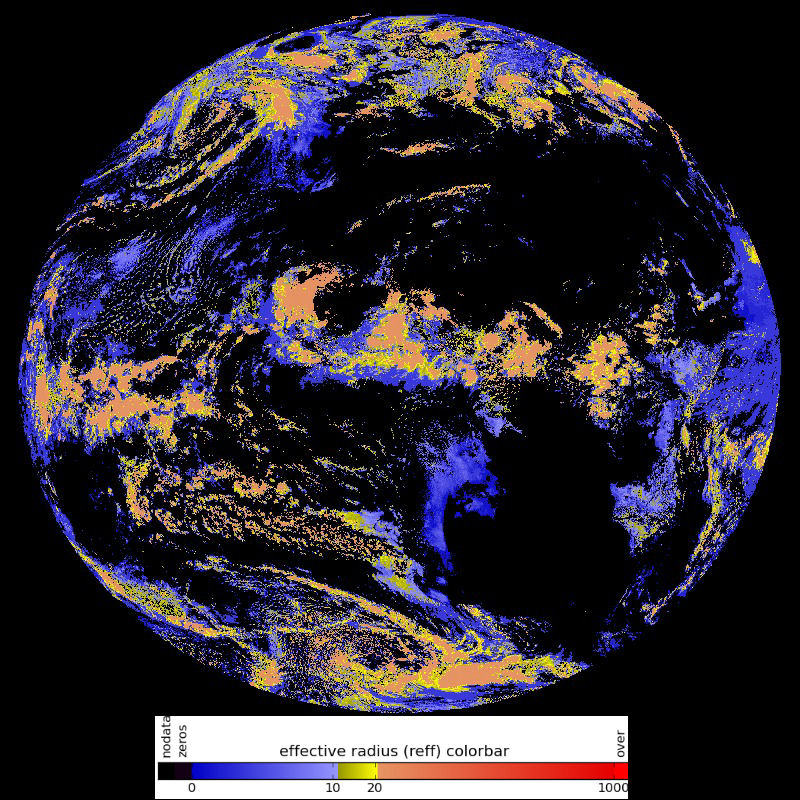
Click on thumbnail for full-sized this image
SEVIRI CMIC cloud top effective radius using the colour palette included in CMIC NetCdF files.