
Convective Rainfall Rate from Cloud Physical Properties
(NWC/GEO CRRPh,v2025)
Table of contents
1. Goal of CRRPh product
2. CRRPh algorithm description
3. CRRPh correction factors
4. List of inputs for CRRPh
5. Description of CRRPh outputs
6. Example of CRRPh visualisation
7. Coverage
Access to "Algorithm Theoretical Basis Document for the Precipitation Product Processors of the NWC/GEO" for a more detailed description of the algorithm.
1. Goal of CRRPh product
Convective Rainfall Rate from Cloud Physical Properties (CRRPh) product, developed within the NWC SAF context, is a Nowcasting tool that provides information on convective, and stratiform associated to convection, instantaneous rain rates and hourly accumulations.
2. CRRPh algorithm description
Day time
CRRPh v2021 is based on a Principal Component Analisis (PCA). Rain intensities estimations are done collecting information from the Cloud Phase, the Effective Radius (Reff) and the Cloud Optical Thickness (COT). All these three parameters are part of the CMIC retrieval. Based on COT and Reff, the Cloud Water is computed (CWP = 2/3 COT * REFF). The Cloud Phase is available during the whole day whereas Reff and COT are only available at day time. Along with the microphysical information, SEVIRI channels are also used: five infrared channels (IR8.7,IR9.7,IR108,IR120,IR134), one visible channel (VIS0.6) that has been normalized and corrected with the sun-earth distance and two water vapour channels (WV6.2,WV7.3)
CRRPh has been calibrated in convective areas. By using PCA’s satellite information has been compressed in two principal components that keep the 95% of the whole variance.
Taking into account the instantaneous rain rates computed in the last hour time interval, hourly accumulations are computed through a trapezoidal integration.
For a better precipitation area location a parallax correction can be applied to this product. This option is chosen by the user through the product model configuration file and it is applied by default. When the Parallax Correction is working, a spatial shift is applied to every pixel with rain rate greater than 0 mm/h.
Night time
One single algorithm is used for the whole day. That means the same inputs used at day time are required at night time. Since CWP and the VIS0.6 channel are only available at day time, an artificial method has been developed to create a pseudo-CWP and a pseudo-VIS06 derived from infrared and water vapour channels, also based on a principal component analysis.
Transition between day to night algorithm is produced whenever the solar zenith angle is greater than 70º. It is also possible to configure the product to only use the night algorithm by setting the sun zenith angle threshold to 0. This would avoid discontinuities in the product at the day/night transition on the cost of degrading performance during day time.
3.CRRPh correction factors:
Cloud Water Path correction factor:
An enhancement correction factor based on the Cloud Water Path (CWP) has been incorporated, being available for the whole day. This way, the CRRPh output have been modified, providing with more rainfall rate in those areas with more content of water.
This CWP enhancement only applies to areas that exceed a specific threshold, being convective cores much more prone to be affected by this correction than areas with stratiform clouds. This correction factor applies to day time and also to night time. Since at night time the simulation of the Cloud Water Path hardly reach values higher than 1500 gm-2 the limit to start applying the correction factor starts at 650 gm-2 and this correction factor increases with higher values of the pseudo-CWP. The threshold at day time starts at 4000 and it is also not steady, it increases with higher values of the Cloud Water Path.
Stability correction:
Like other NWC SAF products do, such as the RDT-CI (Rapidly Developing Thunderstorm – Convection Warning) a stability mask is used. This mask make use of the NWP data to compute several convective indexes: K Index (KI), Showalter (SHW) and Lifted Index (LI). The combination of such indexes allow to identify stable regions where convection is unlikely to happen.
If pixel value of LI index stable (>0) and pixel value of SHW index stable (>3) and pixel value of KI index stable (< 20), then it will considered full stable case at pixel level.
Precipitation output for CRRPh and PCPh is removed in those stable regions. This stable mask is an optional parameter and configurable by the user. It is set to use it by default. Stability correction is used to remove CRRPh output from areas where it is not likely to have rain based on NWP models, because those regions are considered stable. If a black whole inside a precipitating area appears, this effect may be directly attributed to this correction. Another known issue related to this correction is that the orography may produce some unrealistic shapes. These artefacts produced by mountains are steady and it appears in the same places so it can be easily detected.
The more accurate the model is, the more precision excluding those precipitating areas in the CRRPh basic output.
Lightning module:
The lightning algorithm assigns a rain rate to every lightning depending on:
- the time distance (delta tau) between the lightning event and scanning time of the processing region centre.
- the location of the lightning
- the spatial density of lightning in a time interval
Once the precipitation pattern has been computed, it is compared to the CRRPh precipitation pattern in order to obtain the final product. This final product contains the highest rain rate of the two.
4. List of inputs for CRRPh
Satellite imagery
- IR8.7, IR9.7, IR10.8,IR12.0,IR13.4 (Brightness temperature)
- VIS0.6 (Normalized reflectance and corrected with Sun distance)
- WV6.2,WV7.3 (Brightness temperature)
IR10.8 SEVIRI brightness temperature at full IR spatial resolution is a mandatory input to compute Parallax Correction.
GEO-cloud microphysics (CMIC Cloud Optical Thickness, CMIC Effective Radius, CMIC Phase)
- CMIC Phase, Cloud Optical Thickness (COT) and Effective Radius (Reff) parameters are mandatory inputs to CRRPh day algorithm.
- CMIC Phase is mandatory input to compute the CRRPh night algorithm.
Inputs pre-checking:
CRRPh is set to zero in the following cases:
- CMIC Phase output indicates cloud free.
- CWP < 350 gm-2 for both day and night time.
- VIS0.6 normalized reflectivity < 30 for both day and night.
Cloud Water Path threshold to depict rain intensities has been empirically obtained.
Numerical model
Temperature at 1000, 925, 850, 700, 500, 400, 300, 250 and 200 hPa
Geopotential at 1000, 925, 850, 700, 500, 400, 300, 250 and 200 hPa
This information is used by default for parallax correction. In case of lack of NWP parameters parallax correction will be run using a climatological profile.
Ancillary data sets
Climatological profile is necessary as a back up for Parallax correction in case NWP is not available. This information is included in the software package.
Lightning information file for CRRPh product
A file with information on every lightning occurred in a time interval is mandatory to choose the option of adjusting the CRRPh precipitation pattern with the lightning information.
Model configuration file for CRRPh
CRRPh model configuration file contains configurable system parameters in the generation process of CRRPh product. The CRRPh product related parameters refers to ancillary datasets, numerical model data, parallax correction, lightning module, stability correction and cloud water path correction. The complete list of these parameters and the explanation of the most useful ones are available in the"User Manual for the Precipitation Product Processors of the NWC/GEO".
5. Description of CRRPh outputs
CRRPh product is coded in NetCDF format. The available outputs are the following:
crrph_intensity
crrph_intensity output contains the rainfall rates associated to convective clouds. The rain rates can take values from 0.0 to 50.0 mm/h with a step of 0.2 mm/h.
| DAY ALGORITHM | |||
| GEO-CMIC-INPUT PHASE | PHASE INPUT CLASS | COT OR REFF FROM CMIC | CRRPH OUTPUT |
| Liquid | 1 | NO DATA | NO DATA |
| DATA AVAILABLE | crrph_intensity(mm/h)=scale_factor*counts + add_offset | ||
| Ice | 2 | NO DATA | NO DATA |
| DATA AVAILABLE | crrph_intensity(mm/h)=scale_factor*counts + add_offset | ||
| Mixed | 3 | NO DATA | NO DATA |
| DATA AVAILABLE | crrph_intensity(mm/h)=scale_factor*counts + add_offset | ||
| Cloud-free | 4 | NOT APPLICABLE | 0 |
| Undefined | 5 | NOT APPLICABLE | NO DATA |
| No data or corrupted data | FillValue | NOT APPLICABLE | NO DATA |
| NIGHT ALGORITHM | ||
| GEO-CMIC-INPUT PHASE | PHASE INPUT CLASS | CRRPH OUTPUT |
| Liquid | 1 | crrph_intensity(mm/h)=scale_factor * counts + add_offset |
| Ice | 2 | crrph_intensity(mm/h)=scale_factor * counts + add_offset |
| Mixed | 3 | crrph_intensity(mm/h)=scale_factor * counts + add_offset |
| Cloud-free | 4 | 0 |
| Undefined | 5 | NO DATA |
| No data or corrupted data | FillValue | NO DATA |
where:
scale_factor = 0.1
add_offset = 0.0
crrph_accum
crrph_accum output provides hourly accumulations associated to convective clouds and computed using the rainfall rates from the images in the last hour. This output provides precipitation accumulations from 0.0 to 50.0 mm with a step of 0.2 mm
crrph_status_flag
crrph_status_flag provides information on whether parallax correction, lightning algorithm, cloud water path or stability correction have been applied, the inputs used to compute the product and some other aspects:
Data Availability:
Bit 0: Reff or COT not computed (out of cloud, night time, phase not defined)
Bit 1: Phase not computed or undefined
Bit 2: IR band missing (used in parallax correction)
Applied Correction:
Bit 3: Parallax correction applied
Bit 4: Cloud water path correction applied
Bit 5: Stability correction applied
Use of optional data:
Bit 6: Lightning data used
Other information
Bit 8: crrph_intensity was a hole because of the parallax correction, and then was filled by the median filter
Bit 9, 10, 11: Use of bands for accumulation
1: All required bands were available
2: One previous CRRPh band is missing
3: At least two previous CRRPh bands are missing (no consecutive)
4: At least two previous CRRPh bands are missing (some are consecutive)
Bit 12: Accumulation quality flag. Set to 1 if:
not all crrph values are available to perform the accumulation,
OR
any of the crrph_intensity values was set to 0 due to filtering process
OR
Any of the crrph_intensity values was a hole because parallax correction
Bit 13: Accumulation illumination flag:
1: Accumulation computed only with day algorithm.
2: Accumulation computed only with night algorithm
3: Accumulation computed with mixed algorithms.
6. Example of CRRPh visualisation
CRRPh Instantaneous rain rates
Below are shown different images of the instantaneous rain rates CRRPh product, day and night algorithms. It has been obtained at full resolution.
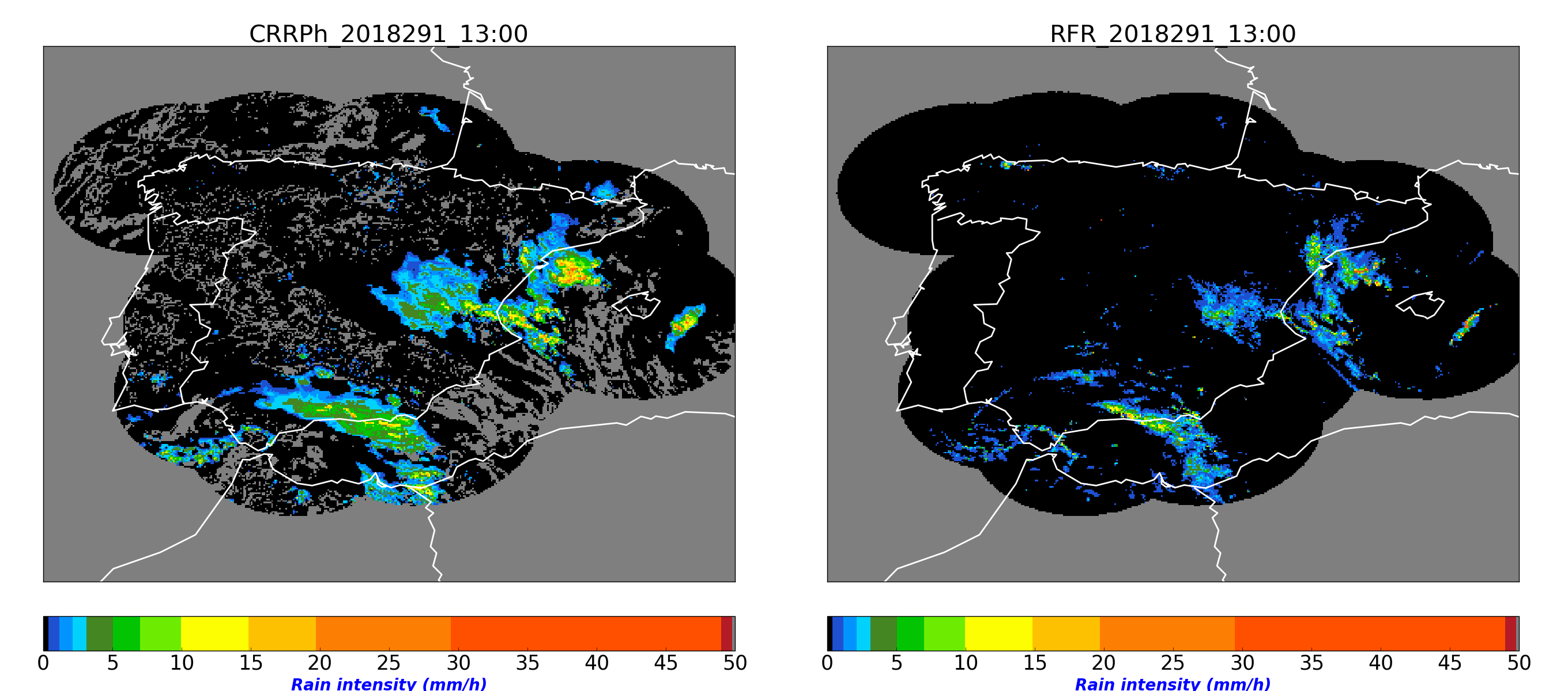
Figure 1: Comparison of CRRPh day product and the Spanish radar on 18th October 2018 at 13:00UTC
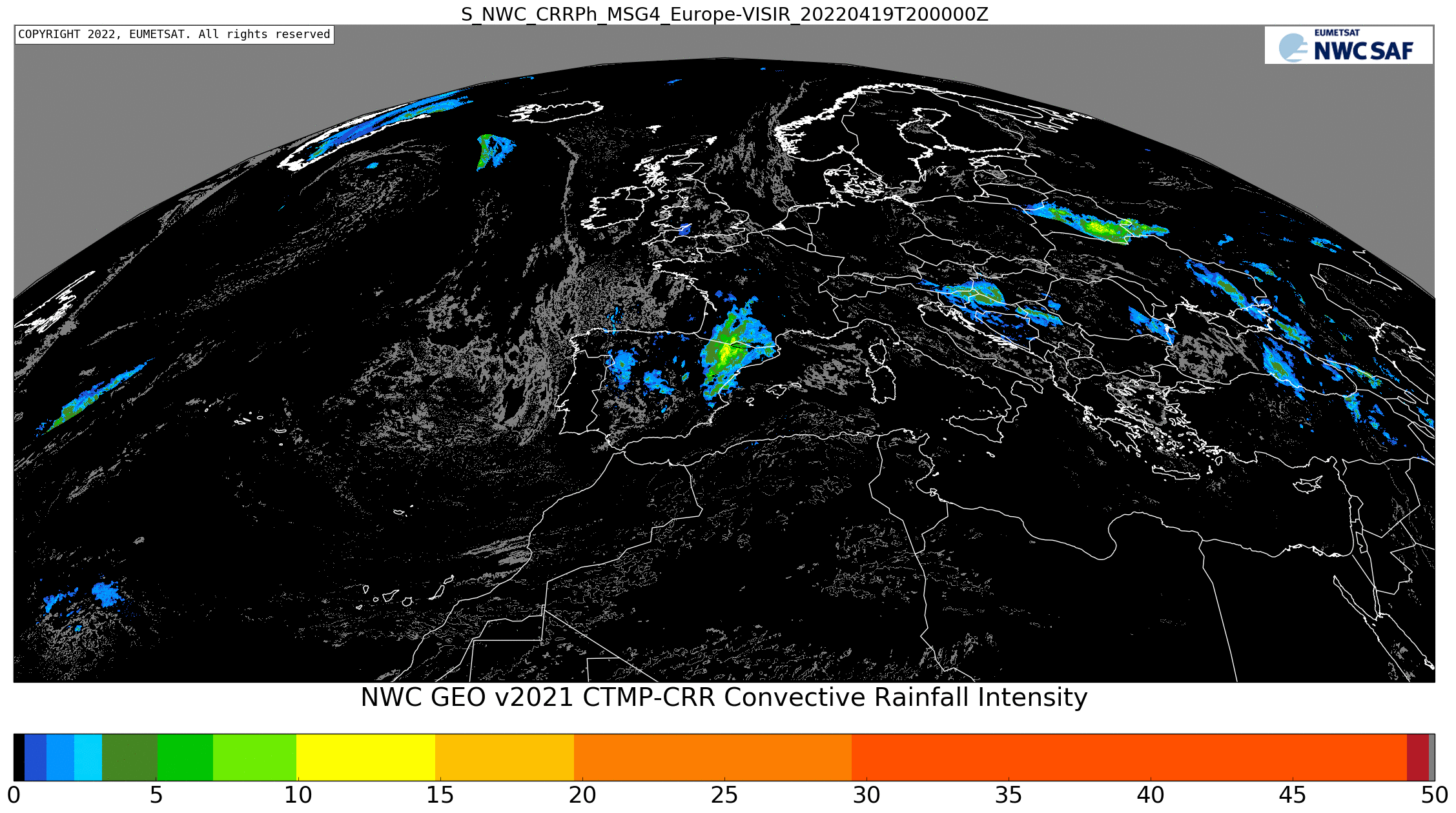
Figure 2: CRRPh instantaneous rain rates for 22th April 2022 at 20:00 UTC over Europe, night algorithm
CRRPh Hourly accumulations
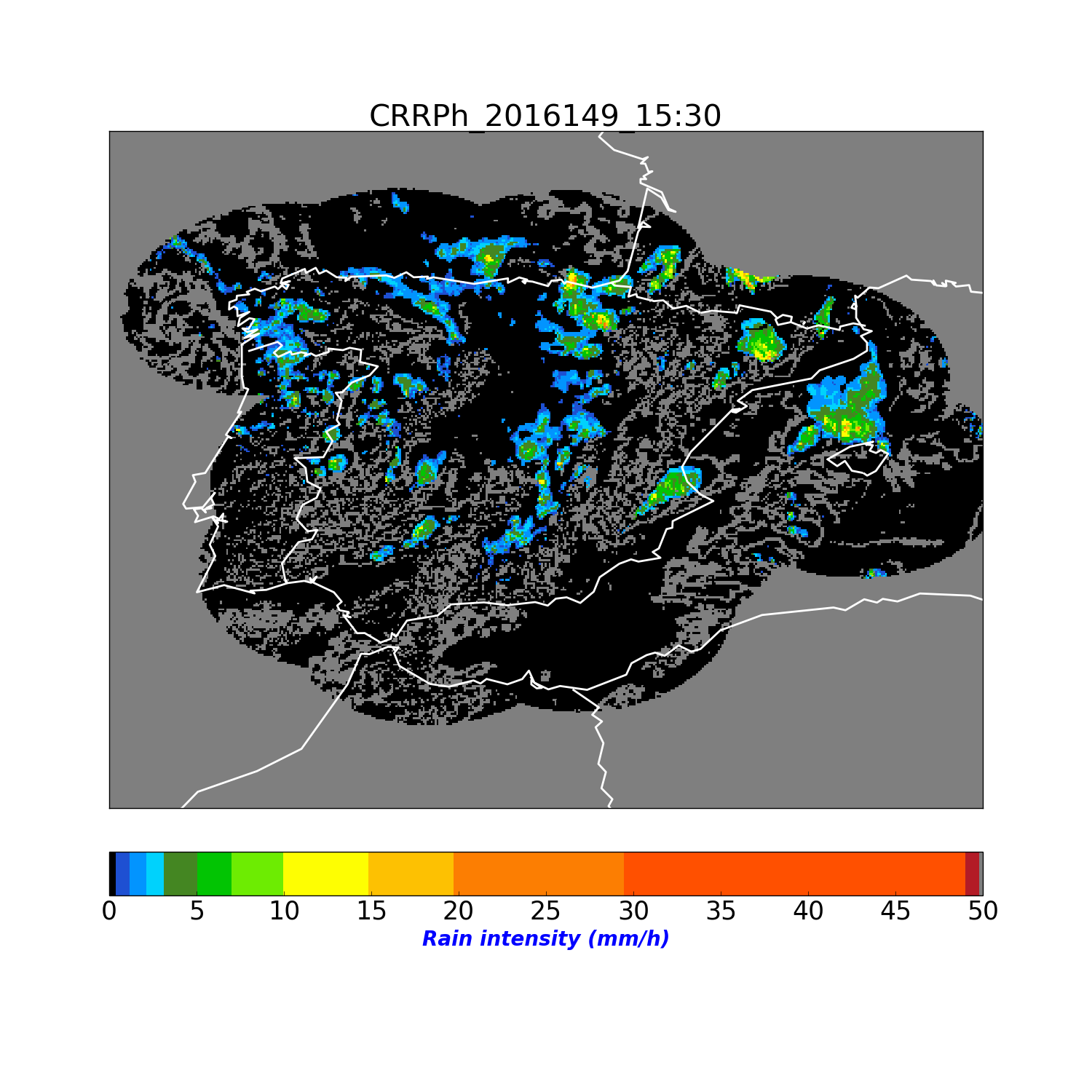
Below is shown an image of the hourly accumulation CRRPh product. It has been obtained at full resolution.
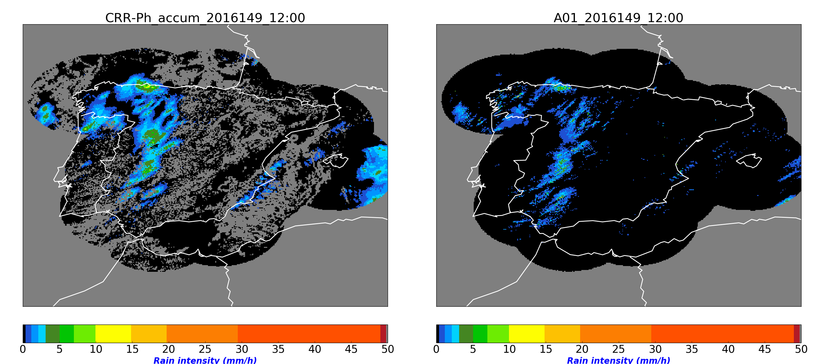
Figure 3: CRRPh hourly accumulations for 28th May 2016 at 12:00 UTC over Spain
7. Coverage
Conventive rainfall intensities and convective rainfall hourly accumulations can be processed by the following satellites: MSG, GOES-16 or HIMAWARI-8.
An example of rain intensity visualization over USA is shown below. It has been obtained at full resolution.
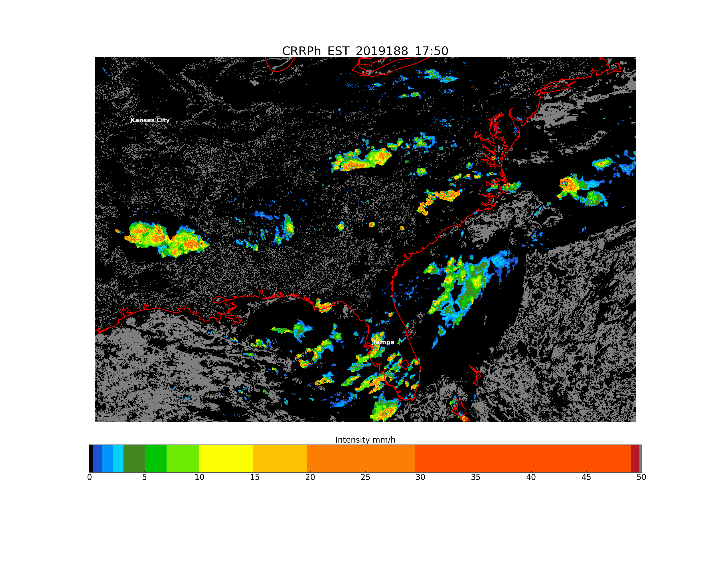
Figure 4: CRRPh product on 7th July 2019 at 17:50 UTC over USA, night algorithm.
References
- Pilewskie, P. and Twomey, S., 1987. Discrimination of ice from water in clouds by optical remote sensing. Atmos. Res., 21:113-122
- Rosenfeld, D., and G. Gutman, 1994. Retrieving microphysical properties near the tops of potential rain clouds by multispectral analysis of AVHRR data, Atmos. Res., 34, 259–283, doi:10.1016/0169-8095(94)90096-5.
- Roebeling, R.A., A.J. Feijt and P. Stammes, Cloud property retrievals for climate monitoring: implications of differences between SEVIRI on METEOSAT-8 and AVHRR on NOAA-17 J. Geophys. Res., 2006, 111, 20210, doi:10.1029/2005JD006990.
- Roebeling, R.A. and I. Holleman, 2009. SEVIRI rainfall retrieval and validation using weather radar observations. J. Geophys. Res., D2120, 114.
- Tapia, A., Smith, J. A., Dixon, M., 1998: Estimation of Convective Rainfall from Lightning Observations, Bull. American Meteorological Society, Vol. 37, pp. 1497-1509.
- Vicente, G.A., Scofield, R.A. and Menzel W.P. 1998: The Operational GOES Infrared Rainfall
Estimation Technique, Bull. American Meteorological Society, Vol. 79, No. 9, pp. 1883-1898. - Daniel Rosenfeld, William L. Woodley, Amit Lerner, Guy Kelman, Daniel T. Lindsey, 2008. Satellite detection of severe convective storms by their retrieved vertical profiles of cloud particle effective radius and thermodynamic phase. J. Geophys. Res. D4, 113.
- Gutierrez, J. M. and Aguado, F.: Quality image for the Spanish Radar National Composite, Proceedings of ERAD 2006, 318-320.
- Judith A. Curry Christopher D. Ardeel Lin Tian: Liquid water content and precipitation characteristics of stratiform clouds as inferred from satellite microwave measurements. Journal of Geophysical Research: Atmospheres, Volume 95, Issue D10, pp. 16,659-16,671 DOI: 10.1029/JD095iD10p16659.
- Nauss, T. and Kokhanovsky, A. A., 2007: Advances in GeosciencesAssignment of rainfall confidence values using multispectral satellite data at mid-latitudes: first results, Advances in Geosciences, 10, 99–102.
- Lahuerta, J.A.,2021: Scientific Report on response to the 2020 ESSL testbed feedback on NWC SAF precipitation products.
- Algorithm Theoretical Basis Document for "Precipitation products from Cloud Physical Properties" (NWC-CDOP3-GEO-AEMET-SCI-ATBDPrecipitation_v1.0.1), v2021
- Product User Manual for "Precipitation products from Cloud Physical Properties" ( NWC-CDOP3-GEO-AEMET-SCI-UM-Precipitation_v2.0.1 ), v2021
- Validation Report for "Precipitation products from Cloud Physical Properties" (PCPh v2.0 & CRRPh v2.0), v2021