
iSHAI Products – Instability & Moisture for Aviation (GEO v2018)
iSHAI (Imaging Satellite Humidity And Instability)
iSHAI provides an estimation of stability and precipitable water, total ozone and skin temperature.
iSHAI provides an estimation of the differences with the background NWP profiles, pointing areas where NWP could give inaccurate forecasts.
Strenghts
• iSHAI diagnoses the instability and numerical model deviations.
• iSHAI is available during both day and night-time.
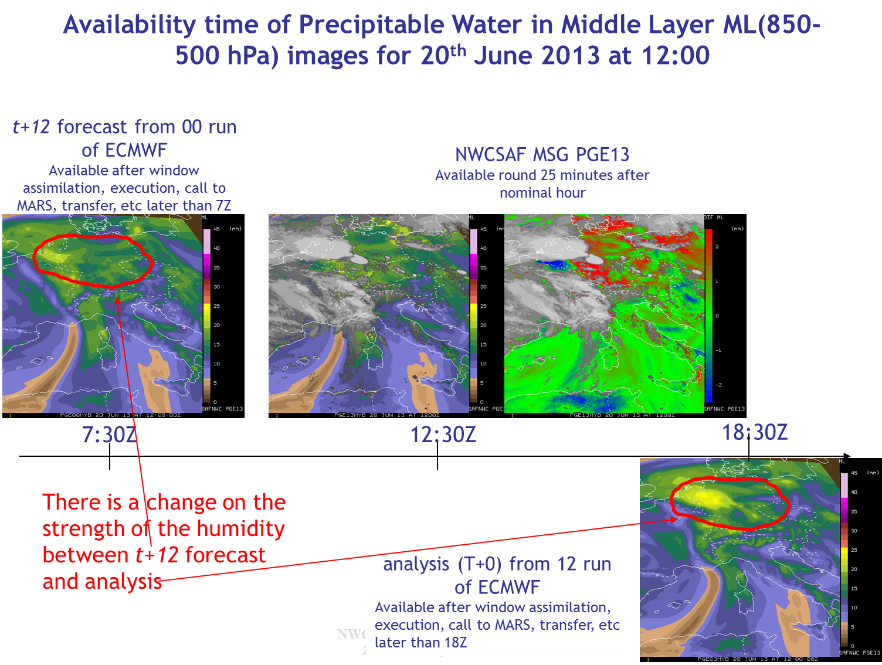
• iSHAI can be generated for every new satellite image from several meteorological geostationary satellites (MSG, Himawari, GOES-R class). This allows to create loops every 15 minutes from MSG satellites (5 minutes in the case of Rapid-Scan; 10 min in the case of Himawari and GOES-R class satellites).
• iSHAI product is generated locally by the users executing the GEO-iSHAI program. This allows use of local NWP model as the NWP background.
Limitations
• Not available on cloudy pixels. Once the clouds develop only information from neighborhood is available.
• The iSHAI product is generated on boxes of N x N pixels (where N is configurable by the users). The size of the default box is 3×3; but can be generated in 1×1. The execution time of iSHAI could be huge for large regions if processed with N too low.
• The cloud mask near edge of clouds tends to produce larger differences with the background NWP.
• MSG satellites have few IR and WV channels: not enough information to greatly modify the background NWP profile.
• The main errors are related to disagreement between the background NWP model used and the true atmosphere. It is recommended to use as input to iSHAI NWP profiles with as much spatial, temporal and vertical resolution as possible.
More Information
To know more: iSHAI description or the tab "Science" at http://www.nwcsaf.org
Real time displays of iSHAI products with MSG satellites over Europe and the Mediterranean Sea are available at:
iSHAI Total Precipitable Water
iSHAI Layer Precipitable Water
iSHAI Stability Analysis Imagery