
South Africa, 18.01.2022. Description
Objective
Evaluation of the convective case in Southern Africa on 18 January 2022.
Your mission is to send warnings (i.e. SIGMETs) to the different airport authorities, reporting of severe weather that could even lead to the decision from these authorities to close the airports or reduce activity, trying that they keep operative as much time as possible. Hence, you cannot make a warning for the whole day and you must do Nowcasting.
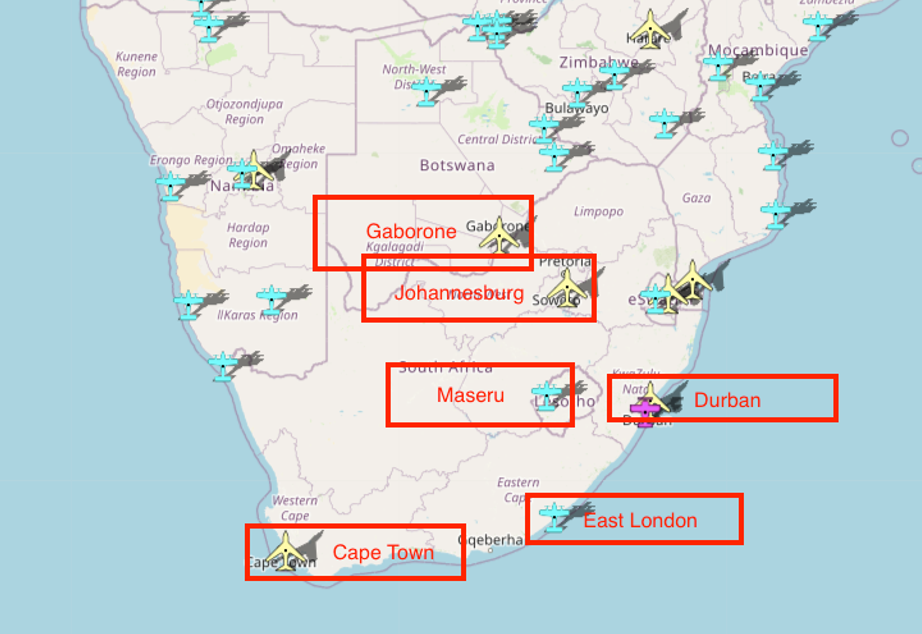
Region of study:
Main airports located in the area:
- Gaborone (Botswana)
- Maseru (Lesotho)
- Johannesburg, Durban, Cape Town, East London (South Africa)
.
TOOLS:
ECMWF model
(ECMWF variables from 20220118 at 0000Z, every two hours between 06Z and 24Z)
Please use these ECMWF variables for a preliminary analysis of the situation, to be later updated with NWCSAF products. Take special interest on:
- Which air masses are involved in the situation,
and how they evolve throughout the day?
- What is the prognosis of convection with these elements?
Which are the main ingredients for this convection?
Cross sections (click here)
Instability images (click here)
Satellite Images
IR120 images Loop (whole day 20220118, every 15 minutes)
WV062 images Loop (whole day 20220118, every 15 minutes)
Airmass RGB Video (whole day 20220118, every 30 minutes, mp4, 5.5 MB)
NWC SAF Products
(whole day 20220118, every 15 minutes).
Update your initial prognosis with the use of the NWCSAF products!
As you have the whole loop of images, please try to evaluate in the initial images of each loop how the situation is evolving, and confirm with the later images that the expected events are actually occurring.
To evaluate convection:
- In a first wave (before convection starts), consider iSHAI products:
Clear air Humidity (tpw / bl / ml / hl) and instability (ki / li / shw) and corresponding differences of these satellite observations with ECMWF forecast humidity (difftpw / diffbl / diffml / diffhl) and instability (diffki / diffli / diffshw).
- In a second wave, when convection starts, evaluate how Clouds evolve (with CT and CTTH products) and Convection evolves (CI and RDT products)
- Evaluate also the behaviour of precipitation (with older CRR product and newer CRRPh product)
- Evaluate also the dynamics with HRW wind product.
CT Loop (Cloud Type)
CTTH Loop (Cloud Top Temperature and Height)
HRW Loop (High Resolution Winds)
RDT Loop (Rapid Developing Thunderstorms)
CI Loop (Convection Initiation)
iSHAI bl Loop (Satellite Humidity and Instability index - Boundary Layer)
iSHAI ml Loop (Satellite Humidity and Instability index - Medium Layer)
iSHAI hl Loop (Satellite Humidity and Instability index - High Layer)
iSHAI tpw Loop (Satellite Humidity and Instability index - Total Precipitable Water)
iSHAI diffbl Loop (Satellite Humidity and Instability index - Boundary Layer, difference with model)
iSHAI diffml Loop (Satellite Humidity and Instability index - Medium Layer, difference with model)
iSHAI diffhl Loop (Satellite Humidity and Instability index - High Layer, difference with model)
iSHAI difftpw Loop (Satellite Humidity and Instability index - Total Precipitable Water, difference with model)
iSHAI li Loop (Satellite Humidity and Instability index - Lifted Index)
iSHAI ki Loop (Satellite Humidity and Instability index - K Index)
iSHAI shw Loop (Satellite Humidity and Instability index - Showalter Index)
iSHAI diffli Loop (Satellite Humidity and Instability index - Lifted Index, difference with model)
iSHAI diffki Loop (Satellite Humidity and Instability index - K Index, difference with model)
iSHAI diffshw Loop (Satellite Humidity and Instability index - Showalter Index, difference with model)
CRR Loop (Convective Rainfal Rate)
CRRPh Loop (Convective Rainfal Rate, physical retrieval)
EXIM-CT Loop (Extrapolated Imagery, CT, 60 min)