
Convection-related hazards for aviation (GEO v2018)
Convection Iniciation
CI provides the probability for a cloudy pixel to become a thunderstorm within a forecast interval. Probability of the formation of a thunderstorm depends on evolution of local condition and on advection of clouds. CI is a pixel product. CI is defined for three time-steps (0-30 minutes, 0-60 minutes and 0-90 minutes) and for four classes of probability (0-25%, 25-50 %, 25-50 %, 75-100%).
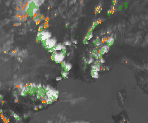
28/06/2010 – 13:00:00TU – Infrared 10.8 µm image superimposed with accumulated Radar signal > 35 dBZ over [13;13h30Z] in green and CI probability for [13-13h30Z]. The colour code for visualization of CI is as follows: yellow for [0-25%] probability of convection, orange for [25-50%] probability, red for [50-75%] probability, magenta for [75-100%].
CI is useful for aviation, as it extends the tactical horizon. It could be useful for airport operations and management.
RDT-CW (Rapidly Developing Thunderstorm - Convection Warning)
RDT-CW provides information on clouds related to significant convective systems:
1) Identification, monitoring and tracking of clouds.
2) Detection of convective cells.
3) Forecast of the convective cells up to +1h.
The object-oriented approach underlying the RDT-CW product allows to add value to the satellite image by characterizing convective, spatially consistent, entities through various parameters of interest.

16/04/2019 – 14:45:00Z – RDT-CW contours over Nigeria superimposed with HRV+Infrared 10.8 µm image and 15 minutes Lightning strokes from WWLLN network. Overshooting Top identified by green triangle. Some attributes displayed in the jauge.
Some attributes of RDT have a strong interest for aviation users, and others have been specifically developed for aeronautical purposes:
a) Phase of Life. An indicator of the stage of development of the cloud.
b) Cooling rate. A clear indicator for the strength of the growth of the cloud.
c) Cloud top pressure. Can be converted in Flight Level (FL).
d) Overshooting Tops (OT): OT are the signature of strong upper-level updrafts, often related to strong turbulence and other hazards (hail).
e) Lightning activity. In the case where RDT-CW is operated with ground-based lightning network or geostationary satellite lightning data.
f) Lightning Jump (LJ) in the case where RDT-CW is operated with high frequency lightning data. LJ is potentially linked to strong events like hail or strong gusts.
g) Convective rain rate. Useful for ground-based operation by aviation community.
h) High IWC (Ice Water Content) occurrence. A daytime attribute related to high altitude ice crystals occurrence, ice crystals may damage the engine of aircraft and interfere with measurements.
i) Severity. A synthetic diagnosis of all attributes related to the activity of the cloud.
RDT-CW produced by Météo-France for the globe with 5 geostationary satellites is incorporated in eWas, EFB (Electronic Flight Bag) developed by GTD company. RDT-CW may be also used for feedback analysis after a weather-related aviation accident.
More Information
To know more: CI description and RDT-CW description or the tab "Science" at http://www.nwcsaf.org
Real time displays of Cloud product with MSG satellites over Europe and the Mediterranean Sea are available at: